A geoportal for monitoring fires and integrating forecasting and early warning systems has just been launched in Madagascar. The initiative of the Malagasy government and its partner, the German International Development Cooperation Agency (GIZ), is part of the national forest fire management strategy.
To address the degradation of Madagascar’s landscape, the Malagasy Ministry of the Environment and Sustainable Development has developed a national fire management strategy. This strategy makes use of effective fire management tools, while taking into account the multiplication of factors involved and the diversification of their origins. This is a geoportal, or more precisely, a public web portal providing access to search and visualization services for geographic or geolocalized data on bushfires.
This fire monitoring geoportal was launched on July 20th, 2021 in Antaninarenina, the Malagasy capital, by the government and its partner, the German International Development Cooperation Agency (GIZ). The data provided by this tool will enable the Madagascan Ministry of the Environment and Sustainable Development to progressively produce a “fire weather forecast” for the entire country. It will produce information on the regions with the most fires, and their season. The fire weather report should also enable the Ministry’s fire management units to be mobilised in time.
More than 10,000 hectares of forest ravaged by fire each year
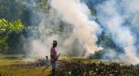
The increase in fire outbreaks is a serious threat to Madagascar’s landscape. According to figures from the Directorate for the Revalorisation of Forest Resources at the Madagascan Ministry of the Environment, 10,000 hectares of forest are lost every year in Madagascar due to bush fires. And statistics provided by the US Space Agency (Nasa) indicate that “90% of the burnt areas correspond to grassy/shrubby savannahs, a little more than 5% to forest areas and less than 5% to crop areas.
Read also-AFRICA: Vegetation cover is burning up
According to the Malagasy Ministry of the Environment, the degradation of land landscapes due to bushfires covers 46% of the southern African country’s surface area, with a cost estimated at 21% of gross domestic product (GDP), estimated at 22.9 million euros in 2019. In addition to the economic and biological losses, this situation reduces the fertility of agricultural land, dries up waterways in the dry season and increases desertification.
Boris Ngounou